Prior to the cadastral maps, the plans of Sabbioneta that have been conserved concern almost exclusively the fortifications of the city. They are in fact documents drawn up for the purposes of military atlases or to celebrate war events (in particular relating to the disputes between Spaniards and Austrians in northern Italy), all of which were carried out in a short interval of time (between the end of the seventeenth century and the first half of the eighteenth).
Gaspare Beretta, Sabbioneta, second half of the 17th century, Milan, Biblioteca Ambrosiana, in Gianfranco Ferlisi, Sabbioneta, città murata, published in Costruire, abitare, pensare. Sabbioneta e Charleville. Città ideali dei Gonzaga, edited by Carlo Bertelli, Universitas studiorum 2017, Mantova, p. 82.
It is the oldest representation of the city, complete not only with fortifications but also its urban layout and main buildings. It is attributed to Gaspare Beretta, an engineer from Milan (1623-1703). The fortified walls are complete with a moat, which also surrounds the castle. There is a lunette ravelin in front of the Porta Vittoria, while beyond the Porta Imperiale the second ravelin is only outlined. Along the external defensive structures there are a number of counterguards, mostly outlined.

D. Joseph Chafrion, Sabioneta, in Plantas de las fortificaciones de las ciudades, plazas y castillos de estado de Milan ofrecelas a la Majestad del Catholico Rey de las Espanas D. Carlos II N. S. La pluma y buril, de D. Joseph Chafrion, captain of Infanteria Espanola del Tercio de Lombardia Y Ingenierio del Exercito, published in Milan in 1687 (table 24), published in Carlo Togliani, L’immagine a stampa di Sabbioneta nel contesto geopolitico della Lombardia spagnola ed austriaca, in Costruire, abitare, pensare. Sabbioneta e Charleville. Città ideali dei Gonzaga, edited by Carlo Bertelli, Universitas studiorum 2017, Mantova, p 106.
It is the layout that most likely serves as a reference for all subsequent similar representations. The city is not represented in its urban layout, referencing only the fortifications and surrounding areas. Beyond the walls, there is a large moat, which also surrounds the castle, and which contains two lunette ravelins, one in front of the Porta Vittoria, and the other in front of the Porta Imperiale.

Vincenzo Coronelli, Map of the walls and fortress of Trezzo and “Sabioneda” side-by-side, 1693, Sabbioneta, Vittorio Rossi Collection.
Engraving designed by the geographer Vincenzo Coronelli (1560-1718), contained in the atlas “Città e Fortezze dello Stato di Milano e Confinanti...” (“Cities and Fortresses of the State of Milan and Borders ...”), published in Venice in 1693.
It represents a simplified design, which leaves out both the interior of the city and also the territory surrounding the fortifications.
The lunette south of the Porta Imperiale is left out, consistent with the Beretta plan preserved at the Ambrosiana. Since Chafrion depicts it, it may have been enlarged by the Spaniards at the time (1687) but not yet completed in 1693, or not represented because Coronelli may have been using outdated information. There are also two fortified lunettes in the moat, between the bastions of San Giovanni and San Nicola and four other similar but smaller structures, protecting the tops of the bastions of San Giorgio, San Giovanni, San Nicolò, Santa Maria. Beyond the moat, the external embankments are enriched with much more detail compared to Chafrion’s plan, with in particular two counterguards to protect the castle and the bastions of Santa Maria and Sant’Elmo.
T. Fritschen, Sabioneda, in Schauplatz des Krieges in Italien, Oder Accurate Beschreibung der Lombardey, 1702, Leipzig, published in Carlo Togliani, L’immagine a stampa di Sabbioneta nel contesto geopolitico della Lombardia spagnola e austriaca, in Costruire, abitare, pensare. Sabbioneta e Charleville. Città ideali dei Gonzaga, edited by Carlo Bertelli, Universitas studiorum 2017, Mantova, p. 111.
The plan is a faithful copy of Coronelli’s drawing.
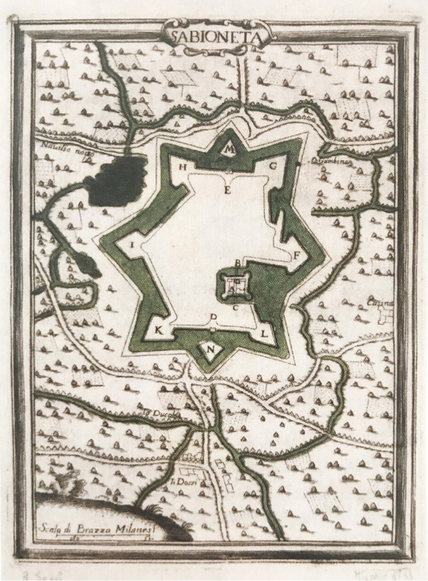
G. B. Sesti, Plan of Sabbioneta, 1707 Sabbioneta, Vittorio Rossi Collection.
Engraving published in 1707 in the Atlas (Plans of the cities, squares and fortified castles in this state of Milan with their declarations...) of Lieutenant General Giovanni Battista Sesti, a collection of the fortified garrisons of the state of Milan.
The walls are complete and surrounded by a large moat that also encompasses the castle and the two ravelins in front of the gates, suggesting a possible derivation from Chafrion.
There are no isolated lunettes in the moat and no details on the external fortifications. Sesti’s atlas was republished in 1733 and 1734 (the latter is an updated edition with a different graphic layout and with the gimmick of the bastion of San Giorgio under attack), but without changing the design of the city and the walls.
G. M. Riva, Plan of Sabbioneta, 1733, Sabbioneta, Vittorio Rossi Collection. Engraving by Giovanni Maria Riva contained in the work of Giovanni Battista Sesti “Piante delle città, piazze e castelli... Aggiontovi gli Attacchi dell’Armi delle MM. Sarda, e Cristianissima...” of 1733.
Apart from the different orientation and the representation of cannonades on the bastion of San Giorgio, the design is essentially identical to Sesti’s original.
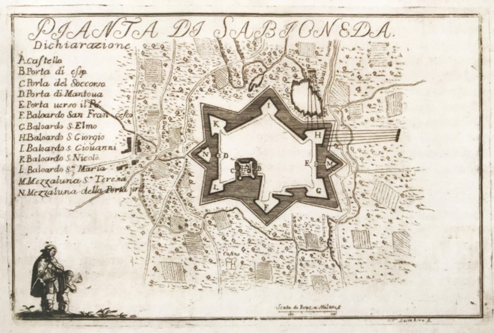
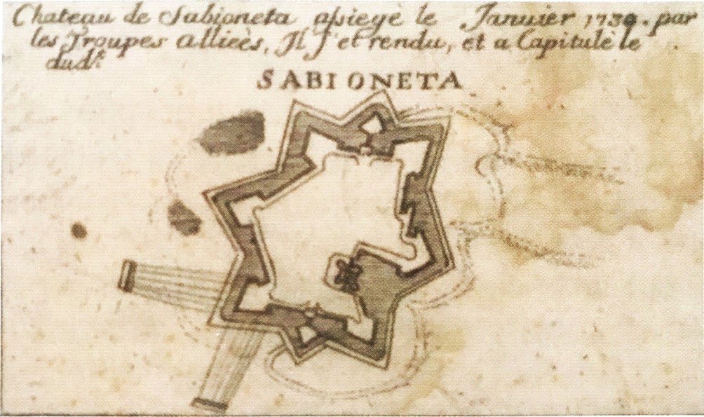
Marc’Antonio dal Re, Chateau de Sabioneta assiegé le janvier 1734 par les Troupes Alliées, in Attaques faites par les troupes des alliez en l’an 1734, published in Carlo Togliani, L’immagine a stampa di Sabbioneta nel contesto geopolitico della Lombardia spagnola ed austriaca, in Costruire, abitare, pensare. Sabbioneta e Charleville. Città ideali dei Gonzaga, edited by Carlo Bertelli, Universitas studiorum 2017, Mantova, p. 115
The engraving was published in Milan in 1734 by the engraver and publisher Marc’Antonio dal Re, in celebration of the reconquest of Lombardy by the Habsburgs following the unexpected occupation of Savoy with the support of France and Spain. The plan invokes the theme of the siege, representing the bastion San Giovanni under fire, although in fact Sabbioneta was not targeted by artillery, but delivered to the Habsburgs after negotiations. The shape of the walls is reminiscent of Sesti’s design.
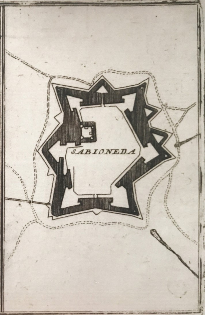
G. Bodenehr, Sabioneta, 1720-1730, Sabbioneta, Vittorio Rossi Collection.
Engraving by cartographer, engraver and publisher Gabriel Bodenehr, author of illustrated catalogues and atlases printed in Augusta.
The plan of Sabbioneta, dated 1720 and 1730, is not, however, part of this collection. The representation of the ravelin to the south of the Porta Imperiale is missing and – as seen also through the shading – it focuses more on the width and depth of the moat and on the external earth defences, clearly depicted as escarpments.
In the large moat, between the bastions of San Giovanni and San Nicola, there are two fortified lunettes.
There is also the “covered road” (i.e. sheltered from the earth embankments), outside the moat, with its parapet.

City Plan of Sabbioneta, 1735, State Archives of Milan (ASMi Militare P.A.b. 381).
The drawing, dated 1735, outlines the two ravelins in front of the gates and a series of external fortifications with several counterguards. With the exception of the ravelins, there are no other lunettes inside the moat.

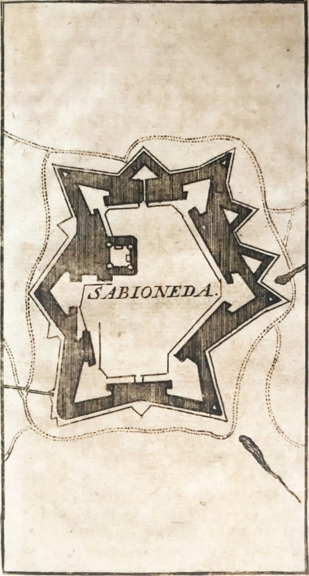
Sabioneta, Georg Christian Kilian, Augusta, kept at the “Achille Bertarelli” Civic Collection of Prints in Milan, dated around 1720, published in Carlo Togliani, L’immagine a stampa di Sabbioneta nel contesto geopolitico della Lombardia spagnola ed austriaca, in Costruire, abitare, pensare. Sabbioneta and Charleville. Città ideali dei Gonzaga, edited by Carlo Bertelli, Universitas studiorum 2017, Mantov, p. 116.
The drawing is in fact a copy Bodenehr’s plan.

Plan de la ville de Sabioneda, Sabbioneta, Vittorio Rossi Collection.
It is an incision derived from or inspiring the drawings of Bodenehr or Kilian, by an unknown author clearly of French origin. The reference to the Duchy of Mantua (which merged with that of Milan in 1746) dates it to before 1745.
The representation is essentially identical to Bodenehr’s.
